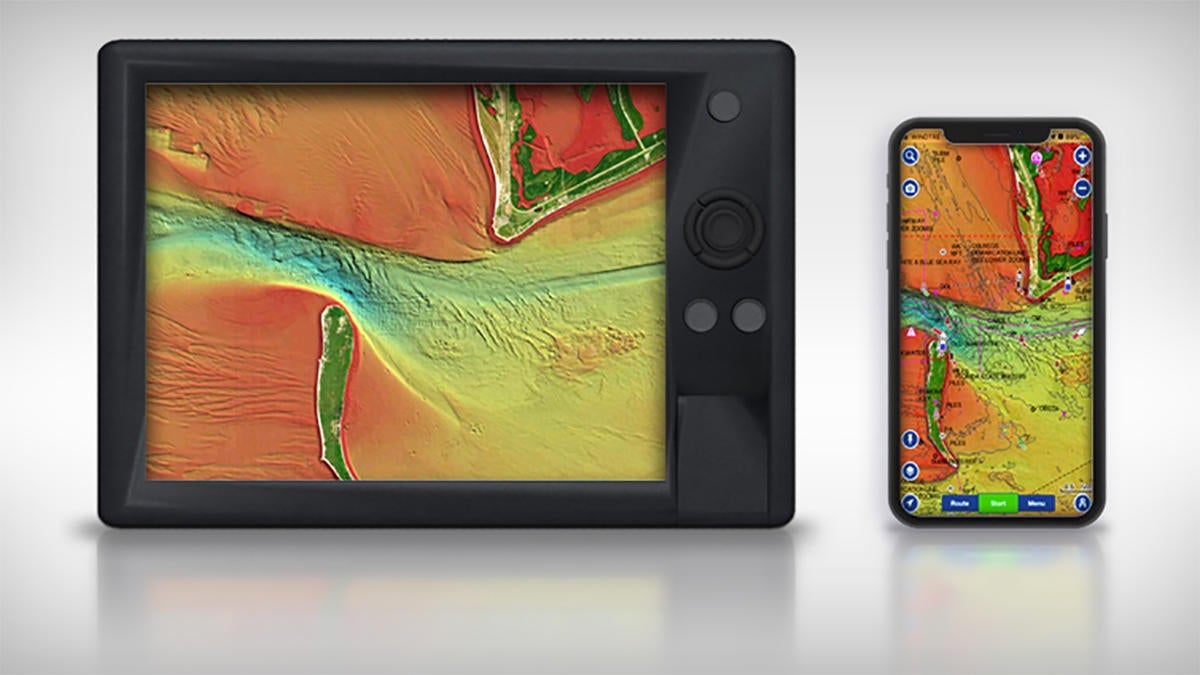
Navionics, a unit of Garmin ® Ltd. (NASDAQ: GRMN), today announced that high-resolution relief shading is now available for Navionics Platinum+ marine charts and HotMaps Platinum lake maps, as well as on the Navionics mobile Boating app, for U.S. coastal waters and more than 150 lakes. Platinum products and the mobile Boating app will also feature updated SonarChartâ„¢ Shading and improved satellite imagery. These updates prepare the most bold and ambitious anglers, boaters, and divers to feel confident and aware of what lies beneath them as they explore a full suite of rich bottom topography content.
“Navionics remains dedicated to providing our customers with the finest, most up-to-date marine cartography coverage on the market,” said Marcello Albanese, Navionics director of sales and business development. “These premium features and content options demonstrate our devotion to equip all those who navigate coastal and inland waters with the most intricate and clear bottom structure detail that they need.”
Relief shading, created from multibeam surveys and high-definition data, provides a multidimensional illustration of bottom topography which can reveal hidden fish-holding formations and diving locations. Now, Navionics customers can enjoy high-resolution relief shading by downloading the chart content to Platinum+ and HotMaps Platinum chart cards for compatible chartplotter systems. The rich color and shadow of relief shading cartography is also available in a subscription to the Navionics mobile Boating app.
Updated SonarChart Shading features expanded coverage and improved satellite imagery for the 2020 boating season. This is the first update since this exclusive Navionics content was launched in 2019. The overlay coverage combines satellite imagery with detailed renderings of bottom structure, based on SonarChart 1-foot bathymetry data, to reveal visual cues of underwater topography at a glance for the ultimate situational awareness.
Navionics Platinum products are preloaded with the satellite overlay and SonarChart Shading layer, 3D view, and panoramic photos to provide customers with easy-to-interpret, colorful imagery of what exists both above and below the waterline. Using a compatible chartplotter system, or a subscription to the Navionics mobile Boating app, Navionics customers can discover the striking detail of these premium charts for an impressive and visual on-the-water experience. These additions complement the existing features of Navionics chartplotting content which include SonarChart, Community Edits, Dock-to-dock Autoroutingâ„¢, and other navigation tools1.
High resolution relief shading, updated SonarChart Shading, and improved satellite imagery are included with an active subscription for Navionics chart cards and the mobile Boating app at no extra cost. Platinum+ and HotMaps Platinum chart coverage areas around the U.S range in price from $199 to $399, depending on the size and location of the coverage area. To ensure compatibility of relief shading and SonarChart Shading, only one of the shading charts can be downloaded to a Navionics chart card at a time. On the mobile Boating app, for your Apple and Android mobile devices, both chart overlays can be downloaded at the same time.